Map and Table calculation
Creating and running scripts
By creating and running a script, you can perform a series of ILWIS operations. The
usage of scripts may save time but is something for more experienced users.
With a script, MapCalc and TabCalc expressions can be performed as well as any ILWIS operation.
Furthermore, some extra commands are possible to show objects, or to perform some file management. For more information on script syntax, see
Appendices : ILWIS expressions,
Appendices : ILWIS commands and Appendices : ILWIS script language (syntax).
To create a script:
- in the Main window, open the File menu and choose Create Script, or
- in the Operation-tree, expand the Create item and double-click New Script, or
- in the Operation-list, double-click the New Script item.
The Script editor appears in which you can type your script expressions.
Example of a script with parameters:
To calculate slope maps in percentages and in degrees:
- Create a script (e.g. 'Slopes')
- On the Script tab of the script editor where the script can be defined: type, to insert a comment line:
//script to calculate slope maps in percentages and in degrees
or type
Rem script to calculate slope maps in percentages and in degrees
- To use the Contour Interpolation operation to create an interpolated height map from segment contour lines, type:
%3 = MapInterpolContour(%1, %2)
Perform a contour interpolation on segment map %1, use existing georeference %2, and write the output to map %3.
Advanced users may wish to define a georeference corners beforehand with a script command; see Appendices : ILWIS script language (syntax).
- To use the dfdx filter
on the interpolated contour map to calculate height differences in X-direction, type:
DX = MapFilter(%3, dfdx)
Filter map %3 with the dfdx filter and write the output to map DX.
- To use the dfdy
filter on the interpolated contour map to calculate height differences in Y-direction, type:
DY = MapFilter(%3, dfdy)
Filter map %3 with the dfdy filter and write the output to map DY.
- To calculate a slope map in percentages from the output of step 4 and 5, type:
%4 = 100 * HYP(DX,DY) / PIXSIZE(%3)
HYP is an internal MapCalc/TabCalc function;
DX and DY are the output maps from the filtering operation;
function PIXSIZE returns the pixel size of raster map %3;
%4 is the output map name of the map containing slope values in percentages.
- To convert the percentage values into degrees, type:
%5 = RADDEG(ATAN(%4/100))
Function ATAN and RADDEG are internal MapCalc/TabCalc functions,
%5 is the output map name of the map containing slope values in degrees.
- After running the script (see step 11), the output maps will be available as dependent maps. The expression by which a map is created is stored in the map's object definition file. The data file for an output map will be calculated when you double-click an output map in the Catalog.
To let the script calculate the data files for the output maps, you may add the following lines to your script:
calc %3.mpr
calc %4.mpr
calc %5.mpr
In fact, by adding only calc %5.mpr, all maps which are part of the process to calculate map %5 will be calculated as well.
- On the Parameters tab of the script editor, select the number of parameters (in this case 5), type a name for every parameter and select for each
input parameter the object type. For example:
| Parameter |
Name |
Type |
| %1 |
Input contour segment map |
Segment Map |
| %2 |
Georef for all output maps |
Georeference |
| %3 |
Output DEM |
Filename |
| %4 |
Output slope map (perc.) |
Filename |
| %5 |
Output slope map (degrees) |
Filename |
- On the Default Values tab, you may assign default objects to your parameters as you would like to use them in the script and/or as you would like to see them in the Run Script dialog box.
For instance:
- The default output name for the Output DEM may be: DEM
- The default output name for the Output slope map (perc.) may be: SlopePct
- The default output name for the Output slope map (degrees) may be: SlopeDeg
- To run the script:
- open the File menu in the script editor and select the Run Script command,
- press the
 Run Script button in the toolbar of script editor, or
- type on the command line of the Main window: Run ScriptName
The Run Script dialog box will appear:

In the Run Script dialog box, all parameter names are listed as specified on the Parameters tab of the script editor.
- If you did not specify default objects on the Default Values tab, you need to select objects for input parameters and/or type object names for output parameters.
- If you did fill out objects on the Default Values tab, the Run Script dialog box will already be filled out with these defaults.
Choose the objects etc. you wish to use, and click OK to execute the script.
Tips:
- To skip the Run Script dialog box, you can also directly fill out all parameters on the command line of the Main window:
run Slopes Contour.mps MyGeoref.grf DEM SlopePct SlopeDeg
In script Slopes, %1 is filled out as Contour.mps, %2 as MyGeoref.grf, %3 as DEM, %4 as SlopePct, and %5 as SlopeDeg.
- Of course, you could also directly type objects names inside the script, instead of using parameters.
- For more information on running scripts, see also How to run scripts.
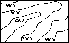
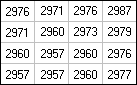
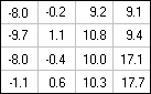
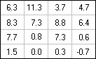
The result of running this script are maps SlopePct and SlopeDeg which are slope maps in percentages and in degrees. Also other maps are calculated during the whole procedure, such as the DEM, DX (height differences in X-direction) and DY (height differences in
Y-direction). The following maps show the input map Contour and very small parts of the other
maps calculated by the script.
Negative values in map DX mean that the slope is downwards when you go from west to east. A positive value indicates an upwards slope. In map DY positive values indicate that when you go from the south to north the slope is upwards and negative values mean that the slope is downwards.
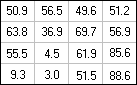
| SlopePct |
|
SlopeDeg |
 |
|
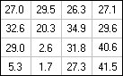 |
The slope maps show the steepness of the slopes irrespective of the direction of the slope.
Mind:
the following slope values are the same: 30�= 58%, 45�= 100%, 60�= 173%, 80�= 567%. As you see, slope values in the Slopepct map can be greater than 100%.
Additionally, you can prepare representations for both maps with the Representation Value/Gradual editor.
You can also create two domain Groups to classify both output maps, e.g.:
classes 0-10%, 10-25%, 25-50%, 50-100%, >100% for the slope map in percentages and
classes 0-6�, 6-12.5�, 12.5-22.5�, 22.5-45�, >45� for the slope map in degrees.
Use these domain groups in the Slicing operation.
You can create your own Help for a script so that you can explain the meaning of parameters to other users of the script. For more information, see the Run Script dialog box.
See also:
ILWIS objects : scripts
Script editor : functionality
Appendices : ILWIS script language (syntax)
How to create a script
How to use parameters in scripts
How to run scripts