Who's onlineThere are currently 0 users and 1 guest online.
User loginBook navigationNavigationLive Traffic MapNew Publications
|
Meuse data set
Short title:
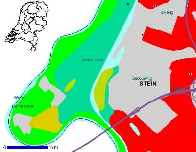
meuse The meuse is a classical geostatistical data set used frequently by the creator of the gstat package to demonstrate various geostatistical analysis steps. The point data set consists of 155 samples of top soil heavy metal concentrations (ppm), along with a number of soil and landscape variables. The samples were collected in a flood plain of the river Meuse, near the village Stein. This zip files contains additional gridded maps (2-40 m resolution), which are used in the exercise 'First steps'. Available layers:
Spatial structure:
proj4:
+init=epsg:28992
Location:
Netherlands
52° 0' 13.5288" N, 4° 46' 22.5228" E
Data owner:
Wageningen University and Research / Rijkswaterstaat
(1 vote)
|
Testimonials"From a period in which geographic information systems, and later geocomputation and geographical information science, have been agenda setters, there seems to be interest in trying things out, in expressing ideas in code, and in encouraging others to apply the coded functions in teaching and applied research settings." Poll |


Recent comments
8 years 34 weeks ago
8 years 51 weeks ago
9 years 8 weeks ago
9 years 20 weeks ago