Who's onlineThere are currently 0 users and 2 guests online.
User loginBook navigationNavigationLive Traffic MapNew Publications
|
Occurrence records for Sturnella magna (USA)
Short title:
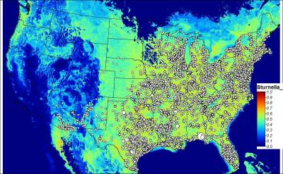
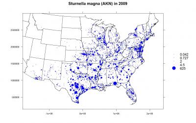
Mdwlark 86971 observation records for Eastern Meadowlark. Obtained from the Avian Knowledge Network (see the original query). After you download the data locally, you can convert it to a point map using:
> AKN <- read.delim("AKN_Query_Results_95201085842.txt")
# fix some columns:
> AKN$Observation.Count <- ifelse(is.na(AKN$Observation.Count), AKN$Obs.Count.At.Least, AKN$Observation.Count)
> AKN$Duration.In.Hours <- ifelse(AKN$Duration.In.Hours==0, 0.5, AKN$Duration.In.Hours)
> AKN$Observation.Date <- as.Date(paste(AKN$Observation.Date))
# records in no / area / time (unfortunatelly Survey.Area.Size is missing)
> AKN$Dens <- AKN$Observation.Count/AKN$Duration.In.Hours
> AKN.pnt <- subset(AKN, !is.na(AKN$Longitude)&!is.na(AKN$Latitude)&is.finite(AKN$Dens),
+      select=c("Global.Unique.Identifier","Longitude","Latitude","Observation.Date",
+      "Dens","Collection.Code","Locality","Survey.Area.Identifier","Observation.Count","Duration.In.Hours"))

# Convert to a point map:
> AEA <- "+proj=aea +lat_1=29.5 +lat_2=45.5 +lat_0=23 +lon_0=-96 +x_0=0 +y_0=0 +ellps=GRS80
+      +datum=NAD83 +units=m +no_defs"
> coordinates(AKN.pnt) <-~Longitude+Latitude
> proj4string(AKN.pnt) <- CRS("+proj=longlat +datum=WGS84")
> AKN.pntXY <- spTransform(AKN.pnt, CRS("AEA"))
> save(AKN.pntXY, file="AKN_Sturnella_magna_USA.RData")
Avian Knowledge Network. 2009. Avian Knowledge Network: An online database of bird distribution and abundance [web application]. Ithaca, New York. Available layers:
Point map showing the distribution of a bird species through time. Description of columns available here. Spatial structure:
'data.frame':   86971 obs. of  8 variables:
 $ Global.Unique.Identifier: Factor w/ 90152 levels "URN:catalog:....",..: 61836 61685 61811 61801 ...
 $ Observation.Date        :Class 'Date'  num [1:86971] 14535 14532 12808 14533 14352 ...
 $ Dens                    : num  1.288 0.667 2 0.941 1.25 ...
 $ Collection.Code         : Factor w/ 20 levels "EBIRD","EBIRD_AK",..: 1 1 1 1 1 1 1 1 1 1 ...
 $ Locality                : Factor w/ 20073 levels "","'Big' Quintana pond",..: 16768 12147 8835 8855 13639 ...
 $ Survey.Area.Identifier  : Factor w/ 21494 levels "L100019","L102957",..: 6825 12997 19949 1722 15230 8877 ...
 $ Observation.Count       : int  3 1 1 4 5 12 1 50 1 1 ...
 $ Duration.In.Hours       : num  2.33 1.5 0.5 4.25 4 3 0.5 3.5 11 9.08 ...
proj4:
+proj=aea +lat_1=29.5 +lat_2=45.5 +lat_0=23 +lon_0=-96 +x_0=0 +y_0=0 +ellps=GRS80 +datum=NAD83 +units=m +no_defs
Location:
United States
42° 26' 26.2608" N, 76° 29' 47.7852" W
Data owner:
Avian Knowledge Network
Reference:
|
Testimonials"...Probably the only shared characteristic would be that these are things you can’t really get unmotivated people to grasp, but if someone is motivated, they’ll find their way in somehow. And enjoy it, after all, it is supposed to be fun, isn’t it?" Poll |


Recent comments
8 years 35 weeks ago
9 years 1 week ago
9 years 9 weeks ago
9 years 21 weeks ago