Who's onlineThere are currently 0 users and 2 guests online.
User loginBook navigationNavigationLive Traffic MapNew Publications
|
Temperatures and precipitation for year 2008 (Croatia)
Short title:
HRclim2008 The data set comprises: (1) location of climatic stations in Croatia, (2) temperature (TEMP) and precipitation (PREC) measurements for year 2008. Temperature is measured with mercury-in-glass thermometers that are situated inside of a wooden shelter, the so called ‘Stevenson’ screen, which allow the air circulation while sheltering the sensors from direct sun exposure. The precision of the temperature readings is tenth of °C. On most climatological stations temperature is measured three times a day, at 7 a.m., 1 p.m. and 9 p.m. The daily mean can be calculated as a weighted average. The rain is collected in a bottle within the rain gauge and readings are usually manual by an observer at 7 a.m. The precipitation collected in the morning refer to the precipitation for previous 24 hours. The point data set consists of a total of:
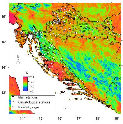
The location of the 159 meteorological stations and 489 rainfall gauges is visible in map on the right. Precipitation of 0 mm is left blank in database, so replace it with 0 mm. If the precipitation is negative or equals 9977, you need to replace it with "NA" values. The missing values in temperature are indicated with -99.9.
Available layers:
Static topographic predictors (grids):
Time-series of RS based predictors:
All grids are projected in the UTM zone 32 system. Position of the climatic stations is in the local LatLon system ("+proj=longlat +ellps=bessel +towgs84=550.499,164.116,475.142,5.80967,2.07902,-11.62386,0.99999445824"). Spatial structure:
proj4:
+proj=utm +zone=33 +ellps=WGS84 +datum=WGS84 +units=m +no_defs
Location:
Croatia
45° 48' 53.6832" N, 15° 58' 42.654" E
Data owner:
Croatian Meteorological and Hydrological Service
|
Testimonials"Just a short word of congratulation about the open-source book project you launched yesterday; this is exactly the idea I have of the word ‘research’ (especially as a free-software advocate myself!), will try to help as much as possible." Poll |


Recent comments
8 years 34 weeks ago
9 years 14 hours ago
9 years 8 weeks ago
9 years 20 weeks ago