Who's onlineThere are currently 0 users and 5 guests online.
User loginBook navigationNavigationLive Traffic MapNew Publications
|
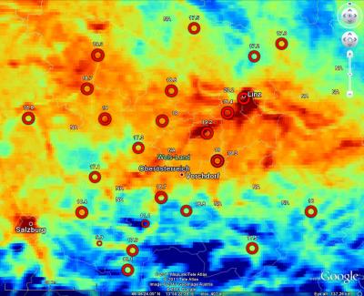
Time-series of temperature measurements for case study in Austria (Oberösterreich region)
Short title:
uppera Temperature measurements for 37 stations for case study in Austria (Oberösterreich region) and a number of auxiliary maps at 1 km resolution. For more info see: www.zamg.ac.at The convert the original MODIS LST Land Surface Temperature & Emissivity 8-Day L3 Global 1km product to degree celsius, use the following formula: LST = MODISLST * 0.02 - 273.15 Available layers:
uppera_LST.zip contains 131 geotifs of monthly averages (MODIS LST) for the given period. Spatial structure:
 > GDALinfo("LST2008_avg.sdat")
rows        156
columns     177
bands       1
origin.x        -48403
origin.y        252901
res.x       1000
res.y       1000
ysign       -1
oblique.x   0
oblique.y   0
driver      SAGA
proj4:
+proj=tmerc +lat_0=0 +lon_0=13.33333333333333 +k=1 +x_0=0 +y_0=-5000000 +ellps=bessel +units=m +no_defs
Location:
Austria
48° 18' 24.984" N, 14° 17' 8.988" E
|
Testimonials"I've been looking at your book - I think it provides nice introductions to some important topics. I'm impressed that it's free!" Poll |


Recent comments
8 years 11 weeks ago
8 years 28 weeks ago
8 years 37 weeks ago
8 years 49 weeks ago