Who's onlineThere are currently 0 users and 3 guests online.
User loginBook navigationNavigationLive Traffic MapNew Publications
|
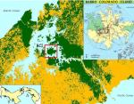
Location of the Barro Colorado Island in Panama To plot the bei dataset in Google Earth use:
library(spatstat)
library(maptools)
library(rgdal)

data(bei)

lon0lat0 <- data.frame(lat=9.15125, lon=-79.8553)
coordinates(lon0lat0) <- ~lon+lat
proj4string(lon0lat0) <- CRS("+proj=longlat +datum=WGS84")
x0y0 <- data.frame(spTransform(lon0lat0, CRS("+init=epsg:32617")))

bei.pnt <- data.frame(x=x0y0[1,1]+bei$x, y=x0y0[1,2]+bei$y, no=rep(1, length(bei$x)))
coordinates(bei.pnt) <- ~x+y
proj4string(bei.pnt) <- CRS("+init=epsg:32617")
bei.ll <- spTransform(bei.pnt, CRS("+proj=longlat +datum=WGS84"))
writeOGR(bei.ll, "bei.kml", "bei", "KML")
|
Latest image Testimonials"Few days ago I have received copies of my book from Lulu.com. The prints are really impressive! If I think about it - Lulu never gave me any physical training about how to make a book cover, how to optimize the cost/readability balance etc; I only followed instructions on their website and submitted the document myself; and now I am looking at prints which are exactly what I would expect from a professional publisher." PollRandom image and variogram model fitted using the Maximum Likelihood (ML) method (right).") |
 | Contact: Tomislav Hengl ([email protected]) |
Recent comments
7 years 18 weeks ago
7 years 36 weeks ago
7 years 44 weeks ago
8 years 4 weeks ago