Who's onlineThere are currently 0 users and 4 guests online.
User loginBook navigationNavigationLive Traffic MapNew Publications
|
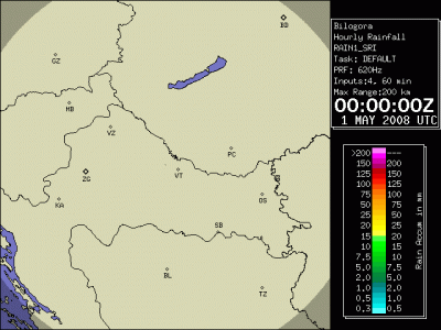
Time series (2008) of radar and MODIS LST images (Bilogora)
Short title:
bilogora This data set contains two time series of images: (a) 92 8-day composite MODIS LST images, and (b) 361 daily precipitation totals estimated using (Doppler-type) ground radar. The study are covers 408 by 408 km; the pixel size is 1 km. Meteorological measurements of temperature and precipitation at referent climatic stations (105) is available in the attached file. If not otherwise indicated, all layers are projected in the UTM33N zone. To obtain more information about the source data and its characteristics, refer to the original data distributors. This data set was prepared for the purpose of testing various space-time interpolation techniques for climatological applications. Available layers:
Spatial structure:
NCOLS 408
NROWS 408
XLLCORNER 466500
YLLCORNER 4878500
CELLSIZE 1000
proj4:
+proj=utm +zone=33 +ellps=WGS84 +datum=WGS84 +units=m +no_defs
Location:
Croatia
45° 53' 0.816" N, 17° 12' 20.34" E
Data owner:
Croatian Meteorological and hydrological service
Reference:
(1 vote)
|
Testimonials"...Probably the only shared characteristic would be that these are things you can’t really get unmotivated people to grasp, but if someone is motivated, they’ll find their way in somehow. And enjoy it, after all, it is supposed to be fun, isn’t it?" Poll |


Recent comments
8 years 35 weeks ago
9 years 1 week ago
9 years 9 weeks ago
9 years 21 weeks ago